![](/images/other/stat-length.png)
Tour du Mont Saint Jacques
fredmig67
Utilisateur
![Longueur](/images/other/stat-length.png)
Longueur
15,1 km
![Altitude max](https://static1.geolcdn.com/siteimages/upload/files/1508320355ic_sort_altitude_max_24dp.png)
Altitude max
2396 m
![Dénivelé positif](https://static1.geolcdn.com/siteimages/upload/files/1508320355ic_sort_den_pos_24dp.png)
Dénivelé positif
823 m
![Km-Effort](/images/other/stat-length.png)
Km-Effort
26 km
![Altitude min](https://static1.geolcdn.com/siteimages/upload/files/1508320355ic_sort_altitude_min_24dp.png)
Altitude min
1836 m
![Dénivelé négatif](https://static1.geolcdn.com/siteimages/upload/files/1508320355ic_sort_den_neg_24dp.png)
Dénivelé négatif
824 m
![Boucle](https://static1.geolcdn.com/siteimages/upload/files/16400158638029165_repeat_loop_refresh_sync_direction_icon.png)
Boucle
Oui
Date de création :
2016-08-02 00:00:00.0
Dernière modification :
2016-08-02 00:00:00.0
![Marche](https://static1.geolcdn.com/sitytour/trail-icons/101.png)
5h37
Difficulté : Difficile
![Scannez ce code QR pour ouvrir la randonnée dans l'application SityTrail](https://capi.geolives.com/qq0zvz2zws4bq2lad0pu/sitytour/trails/607702/qr.png?size=200)
Application GPS de randonnée GRATUITE
À propos
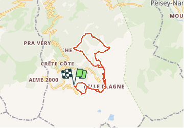
Randonnée Marche de 15,1 km à découvrir à Auvergne-Rhône-Alpes, Savoie, La Plagne-Tarentaise. Cette randonnée est proposée par fredmig67.
Description
Au départ de Plagne Soleil via BellePlagne
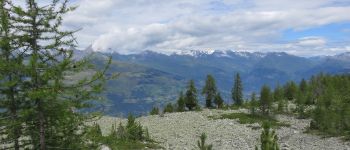
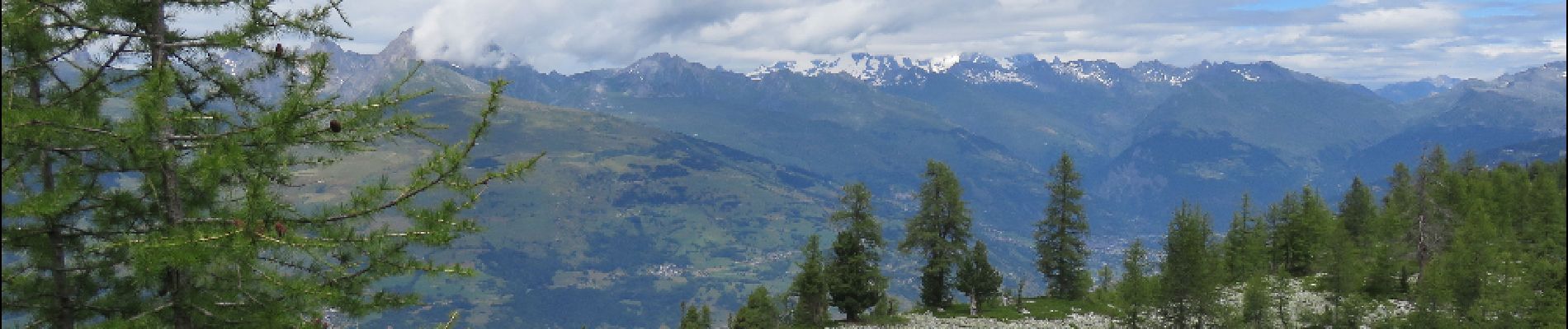
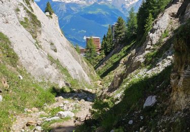
Prairie, pierrier, forêt, un tour qui combine tous les paysages.
Une vue superbe en haut du Mont qui fait oublier la montée.
!! randonnée non adaptée aux jeunes enfants en raison des passages de pierriers.
Localisation
Pays :
France
Région :
Auvergne-Rhône-Alpes
Département/Province :
Savoie
Commune :
La Plagne-Tarentaise
Localité :
Mâcot-la-Plagne
Départ:(Dec)
Départ:(UTM)
319345 ; 5041963 (32T) N.
Commentaires
Randonnées à proximité
![Randonnée A pied Aime-la-Plagne - Le Mont Jovet - Photo](https://media.geolcdn.com/t/375/260/e03d3a37-c792-4b26-aee8-eb362e80dc2f.jpeg&format=jpg&maxdim=2)
![A pied A pied](https://static1.geolcdn.com/sitytour/trail-icons/100.png)
Le Mont Jovet
A pied
Moyen
Aime-la-Plagne,
Auvergne-Rhône-Alpes,
Savoie,
France
![](/images/other/stat-length.png)
11,1 km | 21 km-effort
4h 45min
![](https://static1.geolcdn.com/siteimages/upload/files/16400158638029165_repeat_loop_refresh_sync_direction_icon.png)
Oui
![Randonnée A pied La Plagne-Tarentaise - Les Frasses - Photo](https://media.geolcdn.com/t/375/260/57e5726a-4c56-4000-a6b5-c37a4dc312d4.jpeg&format=jpg&maxdim=2)
![A pied A pied](https://static1.geolcdn.com/sitytour/trail-icons/100.png)
Les Frasses
A pied
Facile
La Plagne-Tarentaise,
Auvergne-Rhône-Alpes,
Savoie,
France
![](/images/other/stat-length.png)
5,7 km | 7,8 km-effort
1h 45min
![](https://static1.geolcdn.com/siteimages/upload/files/16400158638029165_repeat_loop_refresh_sync_direction_icon.png)
Non
![Randonnée A pied La Plagne-Tarentaise - Boucle du Carroley - Photo](https://media.geolcdn.com/t/375/260/3845229a-3558-42f8-bdc8-ddfb57759bc2.jpeg&format=jpg&maxdim=2)
![A pied A pied](https://static1.geolcdn.com/sitytour/trail-icons/100.png)
Boucle du Carroley
A pied
Facile
La Plagne-Tarentaise,
Auvergne-Rhône-Alpes,
Savoie,
France
![](/images/other/stat-length.png)
4,2 km | 7,5 km-effort
1h 41min
![](https://static1.geolcdn.com/siteimages/upload/files/16400158638029165_repeat_loop_refresh_sync_direction_icon.png)
Non
![Randonnée A pied La Plagne-Tarentaise - Sentier Découverte Grande Rochette - Photo](https://media.geolcdn.com/t/375/260/6702af47-efb8-435e-b569-0f7bde146ef0.jpeg&format=jpg&maxdim=2)
![A pied A pied](https://static1.geolcdn.com/sitytour/trail-icons/100.png)
Sentier Découverte Grande Rochette
A pied
Facile
La Plagne-Tarentaise,
Auvergne-Rhône-Alpes,
Savoie,
France
![](/images/other/stat-length.png)
9,2 km | 16,3 km-effort
3h 42min
![](https://static1.geolcdn.com/siteimages/upload/files/16400158638029165_repeat_loop_refresh_sync_direction_icon.png)
Oui
![Randonnée A pied La Plagne-Tarentaise - Boucle de Roche de Mio - Photo](https://media.geolcdn.com/t/375/260/a45fc0d9-32f7-44a2-8151-cf7ff4393f59.jpeg&format=jpg&maxdim=2)
![A pied A pied](https://static1.geolcdn.com/sitytour/trail-icons/100.png)
Boucle de Roche de Mio
A pied
Facile
La Plagne-Tarentaise,
Auvergne-Rhône-Alpes,
Savoie,
France
![](/images/other/stat-length.png)
5,6 km | 12,1 km-effort
2h 44min
![](https://static1.geolcdn.com/siteimages/upload/files/16400158638029165_repeat_loop_refresh_sync_direction_icon.png)
Non
![Randonnée A pied Aime-la-Plagne - Route Balcon - Photo](https://media.geolcdn.com/t/375/260/29321373-2636-40af-bbf6-92b2143917ee.jpeg&format=jpg&maxdim=2)
![A pied A pied](https://static1.geolcdn.com/sitytour/trail-icons/100.png)
Route Balcon
A pied
Facile
Aime-la-Plagne,
Auvergne-Rhône-Alpes,
Savoie,
France
![](/images/other/stat-length.png)
7,4 km | 9,6 km-effort
2h 11min
![](https://static1.geolcdn.com/siteimages/upload/files/16400158638029165_repeat_loop_refresh_sync_direction_icon.png)
Non
![Randonnée A pied La Plagne-Tarentaise - Le Lac Vert - Photo](https://media.geolcdn.com/t/375/260/b6f38b54-08a4-411e-90a2-00a3af0c38ce.jpeg&format=jpg&maxdim=2)
![A pied A pied](https://static1.geolcdn.com/sitytour/trail-icons/100.png)
Le Lac Vert
A pied
Facile
La Plagne-Tarentaise,
Auvergne-Rhône-Alpes,
Savoie,
France
![](/images/other/stat-length.png)
4,6 km | 7 km-effort
1h 36min
![](https://static1.geolcdn.com/siteimages/upload/files/16400158638029165_repeat_loop_refresh_sync_direction_icon.png)
Oui
![Randonnée Marche Bozel - Le Mont Jovet - Bozel - Photo](https://media.geolcdn.com/t/375/260/ext.jpg?maxdim=2&url=https%3A%2F%2Fstatic1.geolcdn.com%2Fsiteimages%2Fupload%2Ffiles%2F1553511878bg_sport_marche.png)
![Marche Marche](https://static1.geolcdn.com/sitytour/trail-icons/101.png)
Le Mont Jovet - Bozel
Marche
Difficile
(1)
Bozel,
Auvergne-Rhône-Alpes,
Savoie,
France
![](/images/other/stat-length.png)
17,3 km | 32 km-effort
4h 45min
![](https://static1.geolcdn.com/siteimages/upload/files/16400158638029165_repeat_loop_refresh_sync_direction_icon.png)
Oui
![Randonnée Marche La Plagne-Tarentaise - Plagne Soleil, La Grande Rochette, Plagne Centre - Photo](https://media.geolcdn.com/t/375/260/851dc525-0560-4e84-bbaf-2d67171a4f8c.jpg&format=jpg&maxdim=2)
![Marche Marche](https://static1.geolcdn.com/sitytour/trail-icons/101.png)
Plagne Soleil, La Grande Rochette, Plagne Centre
Marche
Difficile
La Plagne-Tarentaise,
Auvergne-Rhône-Alpes,
Savoie,
France
![](/images/other/stat-length.png)
8,6 km | 14,5 km-effort
2h 57min
![](https://static1.geolcdn.com/siteimages/upload/files/16400158638029165_repeat_loop_refresh_sync_direction_icon.png)
Non